The map glows on the screen, a digital ghost of the landscape we walk every day
The map glows on the screen, a digital ghost of the landscape we walk every day. It’s not a picture of the mountains; it’s a record of movement. Between August 25 and September 22, Colorado Parks and Wildlife tracked the…
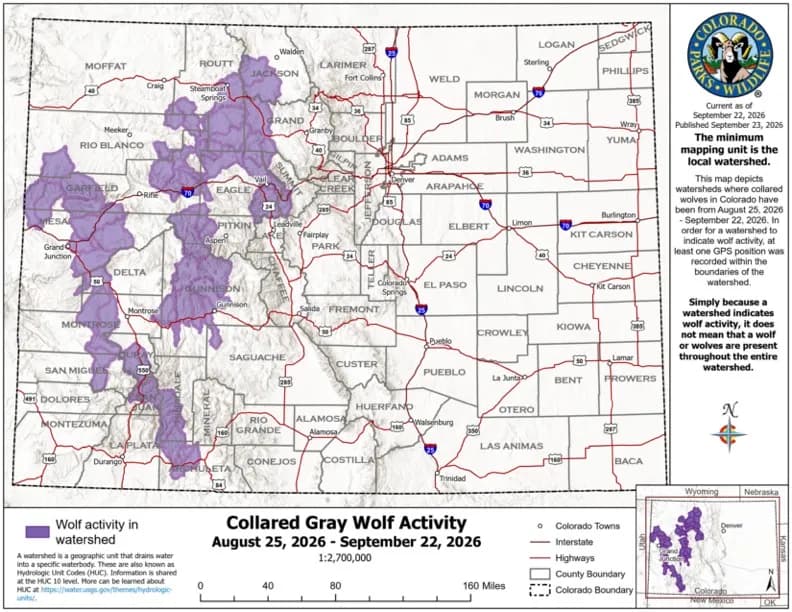
Steamboat Springs —The map glows on the screen, a digital ghost of the landscape we walk every day. It’s not a picture of the mountains; it’s a record of movement. Between August 25 and September 22, Colorado Parks and Wildlife tracked the pulses of GPS signals from collared gray wolves. The dots connect, forming lines that cut across the Western Slope. They stretch from the high country of the Rockies down into the valleys of the San Juans. It is a visual argument that the wolf is not staying put.
The obvious narrative is one of expansion. The agency’s monthly activity map highlights watersheds where at least one GPS point was recorded. In September, that list grew. Activity extended south into Mesa, Montrose, San Miguel, Ouray, San Juan, Hinsdale, and Archuleta counties. But if you look closely, the map reveals a tension between territory and transit. The northwest remains the anchor. Watersheds in Jackson, Routt, Grand, Summit, Eagle, Rio Blanco, Garfield, Pitkin, Delta, and Gunnison counties show persistent presence. This is the heartland of the current population. It is home to the state’s four reproducing packs: the Piney Ridge Pack in Eagle County, the One Ear Pack in Jackson County, the Copper Creek Pack in Pitkin County, and the Three Creeks Pack in Rio Blanco County. These packs are tethered to their ranges. Their pups have left the dens but remain near rendezvous sites where adults bring meat. They are building a home base.
So why are the lines stretching so far south? The answer lies in the difference between a pack and a disperser. Pack wolves defend territory. Lone wolves, however, are on the move. They travel long distances in search of food and mates. The southern extension on the map is likely the trail of these solitary travelers. They are the scouts, testing the edges of the range. Their movements create gaps in the highlighted watersheds, a reminder that a wolf can cover significant ground in the four-hour interval between GPS recordings. The map captures the pause, not the journey.
Yet, beneath the optimism of expanding range, there is a quieter, more complex reality. The total count stands at approximately 32 wolves as of March 31, with only about half wearing collars. Since then, six uncollared wolves have died. The vast majority were euthanized by Parks and Wildlife in response to repeated livestock attacks. Three deaths occurred in a single week in September. This spike has drawn criticism regarding its impact on a nascent population and its efficacy as a management tool. The agency uses euthanization when a pack or individual is linked to three confirmed livestock attacks within 30 days. Prior to this year, only one wolf had been killed for conflict reduction. Now, the tool is being used with greater frequency. The map shows the spread; the mortality data shows the cost.
The Western Slope is changing. The wolf is part of that change. It is not just an animal in the woods; it is a variable in our ecosystem, our economy, and our culture. We watch the map. We follow the dots. We wonder where they will go next. The signal fades, then returns. The line continues.
Keep up with Steamboat Springs
The day's Western Slope news, one email each morning. Free.