White River Forest Starts Prescribed Pile Burnings Across Summit County
The White River National Forest announced the start of prescribed pile burnings in Summit, Eagle, and Garfield counties. Crews will ignite brush mounds to reduce wildfire fuel loads, creating temporary smoke in nearby valleys.
Glenwood Springs —The White River National Forest is firing up the piles.
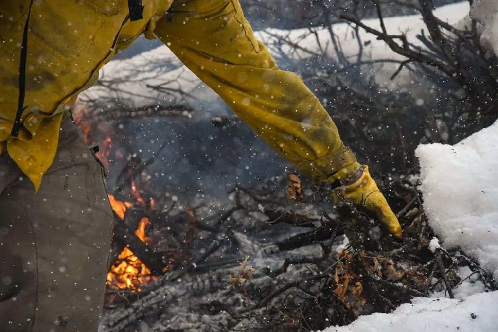
Snow is sticking. That’s the green light. The Forest Service announced this week that prescribed pile burnings will kick off within the next few weeks. The goal is simple: burn the brush before it burns the house.
These aren’t random campfires. Pile burning is a controlled technique. Crews stack branches, logs, and brush into mounds. They ignite the piles to reduce the fuel load. Less wood on the ground means less fuel for a wildfire later. The White River National Forest is the most visited national forest in the country. That means a lot of people are going to be watching the smoke.
The timing is critical. Snow cover needs to be adequate. Weather has to be favorable. If the wind picks up, they wait. Firefighters check the forecast hours before lighting a match. They monitor the area for days afterward.
Smoke is part of the deal. Most of it blows away during the day. But at night, it settles. Valley bottoms and drainages can hold smoke for short periods. If you live in a low spot, expect some haze.
The burn sites are spread across the forest. The list is long. It covers multiple counties.
In Garfield County, crews are targeting the Grizzly Creek Fire piles near Lookout Mountain. That’s south of I-70, east of Glenwood Springs. The area is 118 acres. They’re also burning at the Sunlight Peak communication site. That’s nine miles southwest of Glenwood Springs. The plot is 100 acres.
Eagle County has a heavy workload. The Bighorn Creek Trailhead is on the list. So is Booth Creek. Burnt Mountain is a major site. It’s three miles northeast of Thomasville. The pile there covers 553 acres. Coyote Park is nearby. It’s four miles northeast of Thomasville. The burn area is 381 acres. Piney is also on the map. It’s four miles north of Vail. The Vail Town Shops saw line is included too. That’s just one acre.
Gunnison County sees action in Marble. The Serpentine Trail is the target. The burn area is 18 acres.
Summit County has the most sites. Blue River East and Blue River West are both near the Town of Blue River. The areas are 83 and 17 acres, respectively. Broken Lance Drive in Breckenridge is four acres. Frey Gulch is north of Keystone. It’s 128 acres. Harrigan Stewardship is a big one. It’s ten miles north of Silverthorne. The area is 636 acres. Keystone Gulch is south of Keystone. It’s 63 acres. Lakeview Circle in Silverthorne is two acres. Maryland Creek is five miles north of Silverthorne. It’s 41 acres. Ophir Mountain is south of Frisco. It’s 229 acres. Peak 7 in Breckenridge is 22 acres. Straight Creek is one mile east of Dillon. It’s 28 acres. Willowbrook is one mile west of Silverthorne. It’s 13 acres.
Notifications will be posted online. The Forest Service will update its website and social media pages. Project-specific alerts will go up at FS.USDA.gov/r02/whiteriver. Facebook updates will happen at Facebook.com/whiterivernf.
Air quality data is available at Fire.AirNow.gov. Health impact info is on Colorado.gov.
The smoke will rise. The question is whether you’ll smell it.
Keep up with Glenwood Springs
The day's Western Slope news, one email each morning. Free.