Colorado Wolf Map Shows 45 Animals Scattered Across Western Slope
CPW's latest map reveals 45 collared wolves scattered across the Western Slope, highlighting fluid movement rather than fixed territories.
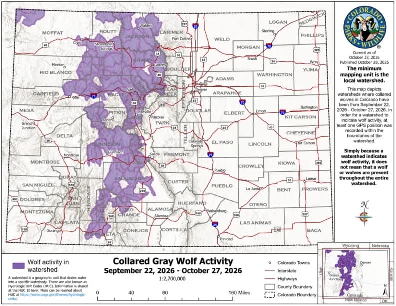
Durango —The GPS tracker blinks. It’s a tiny, rhythmic pulse of data that tells us where a 150-pound predator was four hours ago. It doesn’t tell us where it is now. But it tells us where it was. And in October, that “where” looked remarkably like the entire Western Slope.
The obvious take is that the wolves are everywhere. That’s true. But it’s also incomplete. The real story isn’t just presence; it’s the specific, fragmented nature of that presence. Colorado Parks and Wildlife’s latest activity map, covering Sept. 22 to Oct. 27, highlights watersheds where at least one collared wolf was recorded. The result is a patchwork quilt of activity stretching from the far northwest corner of Moffat County down to the San Juan Basin near Pagosa Springs.
This isn’t a solid block of occupancy. It’s a series of isolated points connected by invisible lines of travel. Wolves move fast. A gap between two highlighted watersheds doesn’t mean the space between is empty; it means the wolf moved through it so quickly that no GPS point was logged there. The map shows stops, not routes.
And that matters because it changes how we think about “wolf country.” We tend to imagine territories — fixed, defended spaces. But the October data suggests something more fluid, especially for the lone dispersers who are doing most of the long-distance wandering. These aren’t pack wolves holding a line. They’re explorers, testing the edges of the state.
The total count remains modest. As of late September, CPW estimated 45 wolves in Colorado. That number includes 20 pups born this spring to four established packs: the Piney Ridge Pack in Eagle County, the One Ear Pack in Jackson County, the Copper Creek Pack in Pitkin County, and the Three Creeks Pack in Rio Blanco County. At six months old, those pups are finally mobile enough to join their parents on longer treks, a significant shift from the summer months when they were tethered to their dens.
There’s also a quiet loss worth noting. The King Mountain Pack in Routt County lost both of its breeding adults this year — one during a collaring operation, the other reportedly to a ranch hand protecting cattle. Yet the four yearlings born to that pack in 2025 are still traveling together, a fragile continuity in the face of sudden demographic shifts.
The geographic spread is undeniable. Activity was recorded in Routt, Jackson, Larimer, Grand, Summit, Clear Creek, Eagle, Rio Blanco, Garfield, and Pitkin counties, extending south into Gunnison, Lake, Chaffee, Saguache, Hinsdale, Mineral, Rio Grande, and Archuleta. It’s a wide net. But remember the caveat: these are only the collared wolves. The untracked individuals remain a variable we can’t quantify, making the visible map a floor, not a ceiling.
If you look closely at the October distribution, you’ll notice a concentration along the central spine of the Western Slope, particularly in the high-elevation corridors that connect the major valleys. This isn’t random. It follows the natural pathways of least resistance, the ridgelines, the river gorges, the old-game trails. The wolves are using the landscape’s existing infrastructure.
One detail often skipped: the interstate agreements. A wolf crossing into Wyoming enters a zone where it can be legally hunted in most areas. In Utah, New Mexico, or Arizona, it can be captured and returned to Colorado under specific protocols. These borders matter. They define the legal status of the animal based on which side of the fence it’s standing on.
So, locals should expect a higher potential for encounter than in previous years, but it’s also more unpredictable. The wolves aren’t staying put. They’re moving. They’re exploring. They’re testing the boundaries of their new home.
Stand there long enough and you start to see the pattern. It’s not chaos. It’s exploration. It’s the early days of colonization, marked by movement, risk, and discovery. The map captures a snapshot of that process - a moment in time where the wolves paused, and the tracker recorded their position.
But the pause is temporary. The next blink will show them elsewhere. Further south, perhaps, or deeper into the mountains. The map will update. The highlights will shift. The story will continue.
For now, though, the October data stands. It shows a species in motion, spreading its wings across the Western Slope, one GPS point at a time. It’s a broad reach. It’s a wide footprint. And it’s a clear signal that the animals are not just present here. They are active. They are moving. And they are getting comfortable with the idea that this vast, rugged landscape might just be home.
The final image is simple: a single, glowing dot on a dark map. It represents a wolf, stopped for a moment, recording its location. It’s a small point of light in a large, dark space. But it’s enough. It’s proof of life. It’s proof of movement. It’s proof that the predators are here, and they are not going anywhere anytime soon.
Keep up with Durango
The day's Western Slope news, one email each morning. Free.



South Fork Residents Face Months of Road Uncertainty After Floods

Cortez Upgrades Recycling Infrastructure With Producer Responsibility Fee Reimbursement